Traffic and Use Study
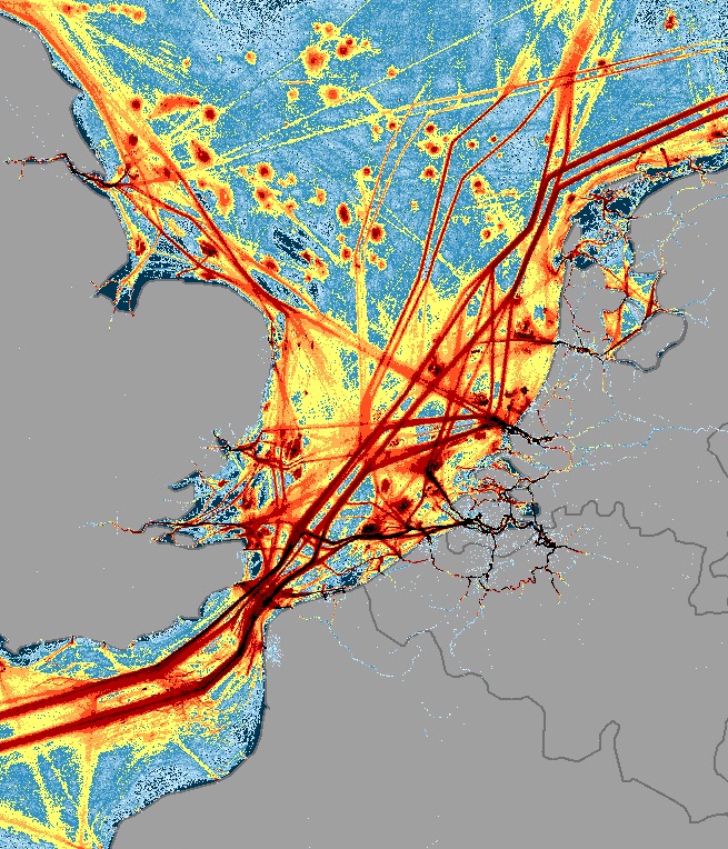 In order to establish the risk of pollution, it was essential to establish maritime traffic patterns and densities. This was undertaken by using AIS data to review shipping density and then defining a route net that identified the most likely routes through the sea area. Actual ship movements were then converted into sequences of route legs within the route net with lateral traffic deviation distributions calculated for each route leg. The resulting traffic model was essentially a database table containing all identified route passages (events, where a vessel passes a route segment) combined with information about passage direction and vessel characteristics.
A cargo transport model was also developed to analyse what types of cargo were on board ships in relation to mineral oil and HNS for different transport routes and to determine the average amount of oil with probability per ship type/ship size per transport route. The extent of other maritime uses (e.g. offshore oil and gas platforms/fields, fishing, wind energy parks, marine sand and gravel extraction) was also reviewed through examination of marine spatial plans for the Greater North Sea and its wider approaches and other data sources.
The project also calculated the risk of marine pollution in 2020 and therefore future increases in ship traffic (2020) and human uses were also analysed based on expected fleet and cargo transport developments and marine spatial planning.
Key Task Deliverables:
- Traffic use/intensity maps
- Report on human use intensity
Next In This Section
Sensitivity Study
The BE-AWARE project identified the highest risk areas and the potential for marine pollution.
Read